The year 2005 was a horrific year for wildfires across all habitats in Arizona. Upper Sonoran Desert areas suffered some of the most devastating fires, notably the Cave Creek Fire north of Scottsdale, Arizona and the Four Peaks fire about 30 km east of Scottsdale. Partly to blame for this destruction were the successive years of severe drought. But the activities and actions of humans are at least, if not more, culpable ... even for fires that were ignited by lightning.
For a hundred years or more cattle have been ranched heavily without regard for the desert's generally low productivity and for the significant changes that this grazing pressure has had on the composition of the flora. Cattle prefer certain grasses, forbs and palatable shrubs over highly spiny or toxic ones. As a result densities of many spiny shrubs and cacti increase with grazing pressure. Examples are prickly pear, chollas, acacias, mesquites and mimosa.
Range managers, including members of the BLM and Forest Service, have made attempts over the years to 'improve' these 'range lands' by introducing various grasses and forage plants. Some worked well for a few years, while others have become great promoters of fire. Buffle Grass, Red Brome and Mediterranean Grass are now exotic invasives that crowd out natives and promote fires.
With years of drought many woody shrubs had died leaving an abundance of dry, highly flammable material. Amongst the dying shrubs were an abundance of the dry, exotic (non-native) grasses. The cattle had been removed to watered fields or sold off because of the drought so that what they would have eaten away provided even more ignition material. The stage for widespread fires was set.
Higher elevations in the Four Peaks area as well as the mountains north of Cave Creek transition from Upper Sonoran vegetation type into Inland Chaparral. Chaparral vegetation naturally burns frequently and is made up of woody species that regrow well after fires. Some of these fire-adapted plants were growing in pockets and fingers of habitat within the Upper Sonoran habitat, and likewise there were patchy plants more typical of Sonoran Desert growing within the Chaparral. These intermingled areas are sometimes called an 'ecotone'. These ecological juxtapositions also likely played a role in the ignition and spread of the fires.
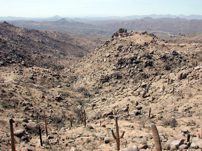
Wildfire raced through the foothills near the Ballantine Trail during the 2005 Four Peaks fire leaving a mostly barren landscape. 70 to 90% of the woody shrubs were burned off and many of the cacti and succulents were killed as well.
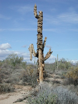
This saguaro was injured by the 1996 McDowell Mountain Park fire and died later from secondary infections.
Sponsored Links
Map of Ballantine Trail and Vicinity
View Larger Map. Directions: From Fountain Hills or Mesa drive north on the Bee Line Highway, SR-87. The trail head is on the right side of highway about 20 miles after crossing the Salt River and the Ft. McDowell Casino.
The GPS coordinates for the trail head:
33.763 N 111.494 W
TopoZone.com Map
Beckoning the residents of metropolitan Phoenix on the far eastern horizon are the Four Peaks, the southern arm of the Mazatzal Mountain range. It's feet are set firmly within the Upper Sonoran Desert and it's summits within the domain of montane conifers. Much of the southwest portions are protected within the Four Peaks Wilderness. There are many trails to choose from and the access to the Ballantine Trail is the easiest. The trailhead parking lot is adjacent to State Hwy. 87 (Beeline Hwy.) about 12 miles beyond the Bush Hwy turn off. The tiny village of Sunflower is a few miles north.
From the parking lot trail #280 takes a three mile loop through the least burned areas. Trail #283 originates off the loop and can be followed 12½ miles to the Cline Trail. Much of the trail is steep and there are stretches with a coating of pulverized gravel that can result in treacherous footing. Trail maintenance crews have been busy rebuilding the steps and erosion control features following the fires. There is no shade for the first 6 or 7 miles so good sun protection is a necessity. The hottest months, May to September, should be avoided and plenty of water should be brought along in any case.
The destruction visible along much of the length of Ballantine Trail will be heartbreaking for many nature enthusiasts. However, for the student of Sonoran Desert natural history this hike - or one similar - is a must. Try to gather clues about why the fire happened and watch the recovery and rapid changes in the months and years following the fire. You will see that many shrubs and herbaceous plants are quick to regrow and colonize. See how the new vegetation has a much different assortment of species than the pre-fire vegetation (compare to nearby unburned areas). The extensive stands of prickly pear will be replaced - with what?
There are several factors promoting this rapid growth. After the fire the soil is enriched with minerals left by the ash of the burned vegetation. When rain arrives the remaining plants get a larger share of the water. Competition for light is also reduced giving many plants a boost.
On March 25th, 2006, plants showing vigorous regrowth were Jojoba, Shrub Live Oak, and Desert Hackberry. Others showing regrowth were Sugar Berry, Toumey Oak, Banana Yucca, a Fremont Cottonwood that had burned right to ground level, Fairy Duster, and within the remains of a mesquite bosque the Aristolochia had resprouted from under ground roots.
Birds, squirrels, lizards, insects and spiders were observed in fair abundance. Many of the plants that were killed or injured are now providing abundant and easy food. A compass barrel when tapped produced a dense swarm of drosophila flies that had bred in the decomposing flesh. Thousands of spiders on gossamer silk were ballooning into and over this opened habitat, their abundance related to the abundant insects. To see ballooning spiders look towards the sunlight, but with a dark hillside background, then hold your hand to block direct sunlight from your eyes. Woodpeckers and lizards also find prey within and near dead or dying plants.
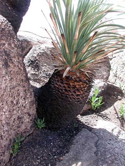
Sotol (Dasylirion wheeleri) is a common element of Upper Sonoran Desert vegetation and can often survive fires well. I found many along the Ballantine Trail that had regrown leaves since the 2005 fire. The bright green seedlings around the base of this sotol are Desert Broom, a plant that is quick to colonize open habitats in the Sonoran Desert.
Sponsored Links
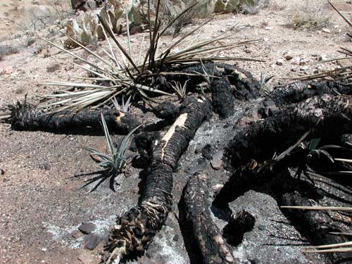
Banana Yucca or Spanish Bayonet (Yucca baccata) is sprouting up from underground roots and stems that escaped the conflagration above. By chance a patch of Englemann Prickly Pear in the background was spared by the flames.
Birds
- Rock Wren -- Salpinctes obsoletus -- S,F,W,Sp
- Cactus Wren -- Campylorhynchus brunneicapillus -- S,F,W,Sp
- Verdin -- Auriparus flaviceps -- S,F,W,Sp
- Black-throated Sparrow -- Amphispiza bilineata -- S,F,W,Sp
- House Finch -- Carpodacus mexicanus -- S,F,W,Sp
- Common Raven -- Corvus corax -- S,F,W,Sp
- Turkey Vulture -- S,F,Sp
- Mourning Dove -- Zenaida macroura -- S,F,W,Sp
- Ladder-backed Woodpecker -- S,F,W,Sp
- Canyon Wren -- S,F,W,Sp
- White-throated Swift -- F,W,Sp
- Gila Woodpecker -- Melanerpes uropygialis -- S,F,W,Sp
- Black-tailed Gnatcatcher -- Polioptila melanura -- S,F,W,Sp
- Gilded Flicker -- S,F,W,Sp
- Canyon Towhee -- Pipilo fuscus -- S,F,W,Sp
Mammals
- Harris' Antelope Squirrel (Amospermophilus harrisii) -
- Audubon's Cottontail -
- Coyote - lots of scat seen
- Gray Fox
Cacti
(In general order of Abundance)
- Engelmann Prickly Pear (Opuntia engelmannii) -
- Buckhorn Cholla (Opuntia acanthocarpa) -
- Saguaro Cactus (Cereus giganteus)
- Compass Barrel Cactus (Ferocactus acanthodes)-
- Graham's Pincushion (Mammilaria grahamii) -
- Hedgehog Cactus (Echinocereus engelmannii) -
- Teddy Bear Cholla (Opuntia bigelovii ) -
Sponsored Links
Trees and Shrubs
- Triangle-leaf Bursage -- Ambrosia deltoidea --
- Foothill Palo Verde (Cercidium microphyllum) --
- Broom Snakeweed -- Gutierrezia sarothrae --
- Velvet Mesquite -- Prosopis velutina --
- Cat-Claw Acacia (Acacia greggii) - mostly along the washes
- Jojoba -- Simmondsia chinensis -- large shrubs with leathery, dark olive green leaves
- Fairy Duster -- Calliandra eriophylla --
- Flat-topped Buckwheat -- Eriogonum fasciculatum --
- Wright's Buckwheat -- Eriogonum wrightii --
- Wolfberry (Lycium spp.) --
- Brittle Bush (Encelia farinosa) --
- Janusia (Janusia gracilis) - a twisty, viney plant
- Desert Hackberry (Celtis pallidum) --
- Canyon Ragweed (Ambrosia artemesiafolia) --
- Scrub Live Oak -- Quercus turbinella --
- White-thorn Acacia -- Acacia constricta --
- Sugar Berry -- Rhus ovata --
- Ocotillo (Fouquieria splendens) --
- Globe Mallow (Sphaeralcea ambigua) -
- Desert Senna -- Senna covesii --
Wildflowers
March 25th
- Desert Globe Mallow -- Sphaeralcia ambigua -- Sp,S,F --
- Dakota Mock Vervain -- Glandularia pinnatifida -- Sp,S,F -- a magnificent clump in full bloom was found at Boulder Flats